The History of the Languedoc: Romans: The
Pont du Gard
   The
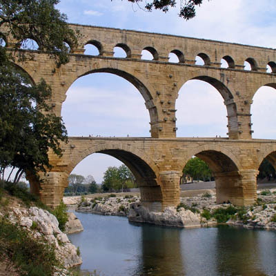
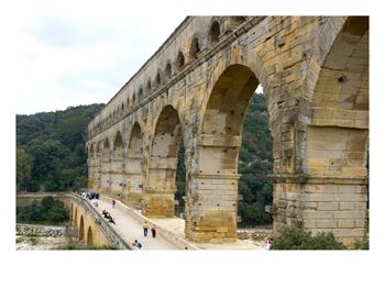
Pont du Gard is a spectacular well-preserved three tiered
Roman aqueduct built over the River
Gard (or Gardon). It is a bridge as well as
an aqueduct, located 25 kilometers north-east of Nimes
in the direction of Avignon. The
Pont du Gard is a spectacular well-preserved three tiered
Roman aqueduct built over the River
Gard (or Gardon). It is a bridge as well as
an aqueduct, located 25 kilometers north-east of Nimes
in the direction of Avignon.
It preserves original style of the era of Augustus.
At almost 50 meters in height it is the tallest the Romans
ever constructed. It is part of the aqueduct built
around the year 20 BC to transport water over 50 kilometers
from the Eure spring near Uz�s to the city of Nîmes.
As there was only 17m fall from the headwaters at Eure to
Nîmes, the incline had to average 0.35mm per metre.
The aqueduct is about 300m long and 49m above of the river.
The bottom arches have spans of 15.75m to 21.5m, and areabout
155m wide and 20m high. On the top of them is
a road (7m wide) which carries modern traffic.
The middle arches have the same spans as those on the bottom
tier. The lengthis about 265m in total. The height of middle
tier is about 21m and its width is 5m. On the
top tier 35 small arches, about 8.5m high and 3m wide, support
the waterway.
The Pont du Gard is one of several World
Heritage sites in the Languedoc. It was added to the UNESCO
World Heritage List in 1985. The Pont du Gard is visited by
more than 1,250,000 tourists every year, making it the 2nd
most visited provincial monument in France.
On the left bank of the river, "la Grande Expo" presents
information about the Pont du Gard. There are
also the inevitable bar, restaurant and boutiques.
Nearby are trails that lead to panoramic viewpoints, the banks
of the Gardon, and picturesque ruins. In the summertime,
the nocturnal lights designed by an American
lighting expert illuminate the bridge.
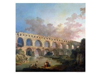
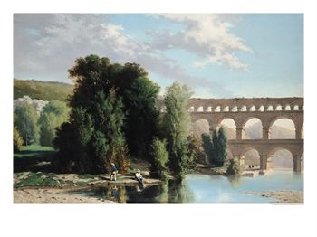
The Pont Du Gard, Nimes, circa 1786 Giclee Print
Robert, Hubert |
|
|
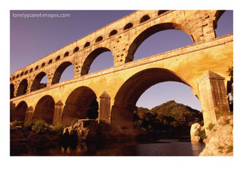
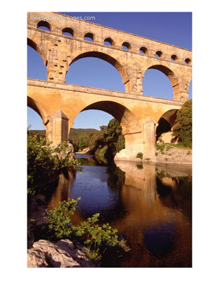
Pont Du Gard, Languedoc-Roussillon, France Photographic
Print, Mayfield, Diana |
|
Some observations by notable visitors:
"The aspect of this simple and noble work struck me
all the more that is was in the midst of a desert where
the silence and solitude increased its effect... I walked
along the three stages of this superb construction, with
a respect that made me almost shrink from treading on it.
The echo of my footsteps under the immense arches made me
think I could hear the strong voices of the men who had
built it. I felt lost like an insect in the immensity of
the work. "
Jean-Jacques Rousseau.
"The preservation of the thing is so extraordinary;
nothing has crumbled or collapsed; every feature remains,
and the huge blocks of stone, of a brownish-yellow (as if
they had been baked by the Provencal sun for eighteen centuries),
pile themselves, without mortar or cement, as evenly as
the day they were laid together. All this to carry a couple
of springs to a little provincial city! "
Henry James.
Pont du Gard, Roman aqueduct, France Photographic
Print
Engelbrecht, Lisa
|
|
|
View of the Pont Du Gard, 1859 Giclee Print
Poinsot, Henri...
|
|
A paper entitled "The Pont du Gard and the Aqueduct
of Nimes" by N A F Smith, published in the Transactions
of the Newcomen Society, 1990-91 Vol 62, discusses engineering
aspects of the Pont du Gard:
As it says, there are a number of puzzling questions relating
to the aqueduct: why it was built, its date, its route, how
it was surveyed, its strange curvature, the unusual third
tier, and the water flow. The author discusses these questions,
offering the reader some interesting theories, concluding
with a description of the castellum divisorium, the delivery
system in Nîmes. On how the aqueduct was surveyed:
"One feature of the aqueduct is especially notable
and that is the amazingly shallow gradient; in a total channel
length of 49.5km the fall is a mere 17m so that the average
gradient is 1 in 2,926 and over one section it is no more
than 1 in 14,285. Gradients have always been a pre-occupation
with writers on Roman aqueducts, one suspects because it
is obviously so easy to measure what was built and compare
it with the advice of the various authorities whose recommendations
are: Vitruvius, not less than 1 in 4,800 or 1 in 200 depending
on which manuscript is consulted; Pliny, who agrees with
Vitruvius at 1 in 4,800; Faventinus, 1 in 40 to 1 in 67;
and Palladius who agrees with Faventinus because he copied
him.
What, by comparison was a critical surveying problem and
one that engineering historians persistently overlook, is
how a water source for city or town, garrison or villa,
was located in the first place and its elevation above the
delivery point established. After all, everything else depended
on this initial measurement being accurate.
Unfortunately we do not really know how this was done.
Most opinion selects the chorobates as the instrument -
a long wooden device - as much as 6m long according to Vitruvius
... Myself, I am inclined to think that more consideration
should be given to the possibility that the Romans used
the A-frame level for water channels, setting the instrument
with its apex uppermost so that the plumb-line intersected
with a mark of scale on the bar ... "
Having discussed how the aqueduct might have been surveyed,
and the evidence that this most challenging task might have
gone wrong, the author concludes that it could well have been
a surveying error that lay behind the unusual third tier of
the bridge, the range of small arches carrying the water channel
itself.
"The spans of these small arches vary subtly because
the engineer cleverly adapted them to match the spacing
of the big arches below. Indeed, a number of writers have
been greatly impressed by the aesthetic fashion in which
the third tier was integrated into the design without considering
that the whole exercise was, very possibly, an unwanted
and unexpected nuisance. In short, perhaps the third level
was an afterthought, so to speak, a remedial modification
to overcome what we were considering just now, a surveying
error."
Pont Du Gard from Riverbank, Languedoc-Roussillon,
France Photographic Print
Mayfield, Diana |
|
|
|
|