Things to See in the Languedoc: Historic
Towns: Aigues Mortes
  Aigues-Mortes
is famous for the well-preserved city walls. The town is located
in the Gard
département, near the northern border of the Languedoc-Roussillon
region in the South of France. It lies in the coastal marshland
of the Petite
Camargue. Its altitude is 0 – 3 m above sea level,
and is liable to flooding. Aigues-Mortes
is famous for the well-preserved city walls. The town is located
in the Gard
département, near the northern border of the Languedoc-Roussillon
region in the South of France. It lies in the coastal marshland
of the Petite
Camargue. Its altitude is 0 – 3 m above sea level,
and is liable to flooding.
Natives of Agues Mortes are called Aiguemortais.
  The
town was once on the coast, but the delta of the River
Rhône constantly changes the landscape here and
it is now several miles in-land, though not far from salt
water. The
town was once on the coast, but the delta of the River
Rhône constantly changes the landscape here and
it is now several miles in-land, though not far from salt
water.
The name Aigues-Mortes means "dead-waters" a reference
to the semi-stagnant salt water marshes (marais and étangs)
referred to as Eaux Mortes (Latin Aquae Mortuae, Occitan
Ayga Mortas) which surround the town. (There are towns
on fast flowing rivers in the Languedoc called Aigues-Vives
- "Live Waters").
    The
foundation of a settlement on this site is attributed to the
Roman
Marius Caius, around 102 BC. The first document mentioning
a place called "Ayga Mortas" (dead waters) dates
from the 10th century. At that time, and for many centuries
afterwards the area was Occitan
speaking. The
foundation of a settlement on this site is attributed to the
Roman
Marius Caius, around 102 BC. The first document mentioning
a place called "Ayga Mortas" (dead waters) dates
from the 10th century. At that time, and for many centuries
afterwards the area was Occitan
speaking.  
In medieval times this area belonged to the The
Counts of Toulouse. These lands were annexed by France
after the Wars against the people of the Languedoc known as
the Albigensian
Crusade, providing France with direct access to the Mediterranean
Sea.
    En
1240, the King of france Louis
IX took an interest in developing the village as a Mediterranean
port. He obtained it by exchanging lands with the monks
of the local abbey (l'Abbaye de Psalmodie), so gaining rights
to gabelle - a tax on local salt production. Aigues was rebuilt
on the orders of Louis as France's first Mediterranean
port. He built a road to the village and constructed the
Carbonnière tower to serve as a lookout tower. En
1240, the King of france Louis
IX took an interest in developing the village as a Mediterranean
port. He obtained it by exchanging lands with the monks
of the local abbey (l'Abbaye de Psalmodie), so gaining rights
to gabelle - a tax on local salt production. Aigues was rebuilt
on the orders of Louis as France's first Mediterranean
port. He built a road to the village and constructed the
Carbonnière tower to serve as a lookout tower.   He
also built the Constance tower to house a garrison. This was
the embarkation point of the Seventh Crusade (1248) and for
the Eighth Crusade (1270). As Louis
IX (now Saint Louis) left for his abortive Crusade to
Egypt in 1270, Sea-water
jousting (Joutes Nautiques) took place here. In 1272,
Louis' son and successor as King of France, Philippe le Hardi,
had the ramparts and rectangular enceinte (curtain wall) built
around the town, an undertaking that took 30 years to complete
As the photograph (upper left) and town plan (upper right)
show, the thirteenth century city is contained within city
walls which are approximately rectangular in plan. The town
is now several miles inland, with a modern town outside the
city walls. He
also built the Constance tower to house a garrison. This was
the embarkation point of the Seventh Crusade (1248) and for
the Eighth Crusade (1270). As Louis
IX (now Saint Louis) left for his abortive Crusade to
Egypt in 1270, Sea-water
jousting (Joutes Nautiques) took place here. In 1272,
Louis' son and successor as King of France, Philippe le Hardi,
had the ramparts and rectangular enceinte (curtain wall) built
around the town, an undertaking that took 30 years to complete
As the photograph (upper left) and town plan (upper right)
show, the thirteenth century city is contained within city
walls which are approximately rectangular in plan. The town
is now several miles inland, with a modern town outside the
city walls.
  . .
|
  The
town has led a relative tranquil time since its foundation,
apart from an incident in 1893. In that year nine Italians
were killed and hundreds injured in the course of a
conflict between the French and the Italians who worked
in the salt evaporation ponds of Peccais. The
town has led a relative tranquil time since its foundation,
apart from an incident in 1893. In that year nine Italians
were killed and hundreds injured in the course of a
conflict between the French and the Italians who worked
in the salt evaporation ponds of Peccais.
|
|
Trivia
The action in Ernest Hemingway's posthumous
novel The Garden of Eden, takes place
in Aigues-Mortes. |
|
|
|
    Today
the town is a major tourist attraction, smaller than but comparable
to the walled city of Carcassonne.
Distinctive Camargue bulls and Camargue
horses are bred in the surrounding countryside. The local
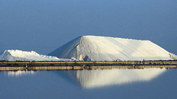
economy also depends on the production of sea salt, wine,
and asparagus. Today
the town is a major tourist attraction, smaller than but comparable
to the walled city of Carcassonne.
Distinctive Camargue bulls and Camargue
horses are bred in the surrounding countryside. The local
economy also depends on the production of sea salt, wine,
and asparagus.
  As
the crow flies, Aigues-Mortes is 32.5 km (20.19 mi) from Nîmes
and 26 km (16.16 mi) from Montpellier.
By road, it is about 35 km (21.75 mi) from Nîmes,
and 30 km (18.65 mi) from Montpellier.
A rail branch line from Nîmes
passes through Aigues-Mortes to its terminus on the coast
at Grau-du-Roi. As
the crow flies, Aigues-Mortes is 32.5 km (20.19 mi) from Nîmes
and 26 km (16.16 mi) from Montpellier.
By road, it is about 35 km (21.75 mi) from Nîmes,
and 30 km (18.65 mi) from Montpellier.
A rail branch line from Nîmes
passes through Aigues-Mortes to its terminus on the coast
at Grau-du-Roi.
Aigues-Mortes lies on the
Canal Rhône-Sète, an extension to the Canal
du Midi, built by Pierre-Paul
Riquet a notable
Languedoc resident. The Canal is popular for boating
holidays and through France's
extensive canal network provides a way to get to the Languedoc
from the Atlantic Ocean, Northern France and Mediterranean
Sea. The town lies next to a number of canals:
- The the
Canal Rhône-Sète (mentioned above) rom
the River
Rhône to Sète
flowing from the north-east towards the west
- The Canal de Bourgidou to the south-east, joining the
Petit
Rhône through other canals on the border between
the departments of the Gard and the Bouches-du-Rhône
- The Grau du Roi, dating from the middle ages, joining
the Mediterranean
Sea at a port also called the Grau-du-Roi.
 
Coordinates 43°34'03 N, 04°11'36 E
INSEE - 30003
Postal code - 30220
Population 6,000
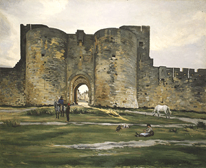
A nineteenth century painting by Frédéric
Bazille.
Porte d'Aigues-Mortes, dite Porte de la Reine. 1867
Oil on Canvas 31.7 x 39.4 in. (80.5 x 100 cm).

Note the surrounding marshland
including the distinctive
Camargue horse |
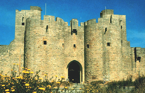
A recent photograph of the same gate
The Queen's Gate
 |
The present Languedoc
and Provence,
together represent the area covered by the ancient Roman's
first province outside Italy. The Camargue, lying in the Rhone
Delta, is positioned between the Languedoc and Provence. For
more on Provence and the Provençal town of Aigues Mortes,
click on the following link which will open a new window to
Beyond
the French Riviera www.beyond.fr 

Louis IX Embarks for the Crusades at Aigues Mortes
Sailing First to Cyprus Giclee Print
|
|
|

Aigues Mortes Ramparts, Languedoc, France Photographic
Print
Wheeler, Nik
|
|
Photographs

St. Louis (1214-70) Leaving Aigues-Mortes, Illustration
from "Histoire Des Croisades" Giclee
Print
Dore, Gustave
|
|
|

The City Walls of Aigues-Mortes, 1867 Giclee Print
Bazille, Frederic
|
|
|

