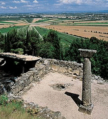
![]() The
prehistoric fortified hilltop settlement (oppidum) at Ensérune
is one of the most important pre-Roman sites in Europe.
The archaeological site here is famous for its scientific
value, specifically the size of the site and the number
of articles found there.
The
prehistoric fortified hilltop settlement (oppidum) at Ensérune
is one of the most important pre-Roman sites in Europe.
The archaeological site here is famous for its scientific
value, specifically the size of the site and the number
of articles found there.
The oppidum of Ensérune is located just off the RN9 in the Hérault département, between Béziers and Narbonne, on a hill overlooking the ancient Étang of Montady. This ancient hill-town can be found near the modern village of Nissan-lez-Enserune, near to the Canal du Midi and to an old Roman road, the Domitian Way (Via Domitia).
Occupation dates from the late Bronze Age and the early Iron Age (8th and 9th centuries B.C.), which were periods of change in the ways of living of the proto-historic populations of what is now southern France. In its earliest phase it consisted of huts made of perishable materials arranged without any apparent order. The settlement of people on large elevated sites known as oppida, followed a long period of semi-nomadism.
Organisation in oppida went together with the intensification of trade at the end of the 7th century and then more intensely with sea trade with the Phoenicians and the Greeks and with Iberia. Trade seems to have gone hand in hand with the development of permanent constructions and fortifications from the 5th century onwards.
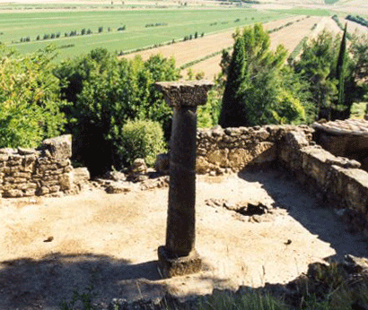
![]() The
oppidum at Ensérune was occupied continuously from
the 6th century BC to the beginning of the first century
AD. It was restructured and fortified twice, first during
the intensification of trade in the 5th century and then
again at the end of the 3rd century when the habitations
covered the whole plateau. It was at this time that the
settlement experienced its most important development.
The
oppidum at Ensérune was occupied continuously from
the 6th century BC to the beginning of the first century
AD. It was restructured and fortified twice, first during
the intensification of trade in the 5th century and then
again at the end of the 3rd century when the habitations
covered the whole plateau. It was at this time that the
settlement experienced its most important development.
The success of the Gallo-Roman economic organisation in the first century BC led to the progressive desertion of oppida in the area. Romans favoured settlements in plains.
There is a museum on the site which offers a slide show, and a display of some of the archaeological remains found on the site, as well as giving more information about the fort and the nearby field system.
From the high point of the site, there is a panoramic view of the Montady Étang (or Étang de Montady)
Location (Enserune): 43°18 38 N, 3 6 55 E
Site Type: vicus
Site Periods: Celtic, Roman, Late Antique
Roman Province: Narbonensis I
Tél : 04 67 37 01 23 - Fax : 04 67 37 27 39
all year round
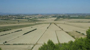
The Montady Etang

![]()
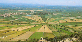
![]() This
was once a lake, but it was drained in the Thirteenth century.
by channels linked to a central sump. The roughly circular
lake left a circular plot of land which was carved up into
wedge shaped slices which you can still see today clearly
visible on maps and aerial photographs (centred at 43°19
12 N, 3°07 24 E ).
This
was once a lake, but it was drained in the Thirteenth century.
by channels linked to a central sump. The roughly circular
lake left a circular plot of land which was carved up into
wedge shaped slices which you can still see today clearly
visible on maps and aerial photographs (centred at 43°19
12 N, 3°07 24 E ).
 |
 |


