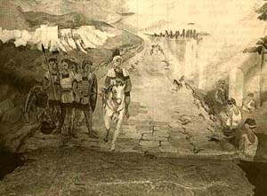


 The
Via Domitia, the oldest Roman road in Gaul, and one of the
oldest Roman roads anywhere. It links Rome in Italy
to Cadiz in Spain, and is part of an immense road network
of more than 70,000 miles, built by the Romans
over eight centuries. It runs from one end of the
Languedoc-Roussillon
to the other, through four of the five departéments
of the Languedoc-Roussillon
(Aude,
Gard,
Hérault,
and Pyrénées-Orientales).
only 15 miles or so from the Mediterranean
Sea, providing an easy way to explore the region's landscapes
and history.
It was constructed in 118 BC by the proconsul, Ghaeus Domitius
Ahenobarbus, and was built around the time of the first
Roman colony in Gaul, Colonia Narbo Martius, which is now
known as Narbonne.
It met the Via Aquitania, which led toward the Atlantic
Ocean via Toulouse and Bordeaux.
Over 2000 years ago the territories of the Gaulish tribes
barred Roman access by land to its possessions in Iberia.
In 118 BC, Cneus Domitius Ahenobarbus crossed the Rhône
with his legions. He had to establish control, and
set up garrisons (like the one at Narbonne) to protect the
colonies, The military road he built still bears his name:
the Via Domitia or Domitian Way. It rapidly became a major
route for communications and commerce.

 The
road allowed Rome to control the wholeof southern Gaul,
distributing agricultural land to Roman
colonists and building new towns along the way.
Apart from exchanges between Rome and its colonial cities,
crossroad settlements developed all along the road, linking
it with neighbouring towns, and creating a new the local
economy.
A modern road (the A9) hides the original materials in
many places, but whole sections of the foundations and engineering
works (such as bridges and mile-posts) can still be seen.
Some interesting places along the way include,
This route was probably the one taken by Hannibal
and his famous elepants in 218 BC on his way to the Alps
(before the Via Domitia was built).
In between the cities that it linked, the Via Domitia was
provided with a series of mansii at distances of a day's
journey for a loaded cart, at which shelter, provender and
fresh horses could be obtained for travellers on official
business.

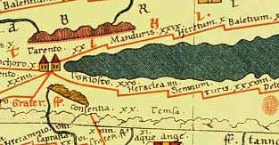
 The
route as it was in Late Antiquity is represented in schematic
fashion on the Tabula Peutingeriana, an itinerarium showing
the cursus publicus, the road network in the Roman Empire.
(a small section is shown on the right)
This route of the Via Domitia is:
Briançon (Brigantio)
Chorges (Caturigomagus)
Gap (Vapincum)
Le Monetier Allemont (Alabons)
 Embrun
(Eburodunum)
Sisteron (Segustero)
Notre Dame des Anges (Alaunium)
Céreste (Catuiacia)
Apt (Apta Julia)
Notre Dame des Lumières (Ad Fines)
Cavaillon (Cabellio)
Saint-Rémy-de-Provence (Glanum)
Saint Gabriel (Ernaginum)
Beaucaire
(Ugernum). This was the point at which the Via Domitia crossed
the Rhône and entered the Languedoc-Roussillon.
On the road on towards Nîmes, between the two towns is an
8 km (5 mile) stretch of the Via Domitia which is well preserved,
with even three of its mile posts still in place. Click
here for more on Beaucaire.
Mas des Tourelles. 8 km from Beaucaire (on the D38)
is an ancient Gallo-Roman villa with workshops and pottery
kilns, which probably dates from the Augustan period.
Modern actors in togas recreate the Roman wine-making process,
though the fact that they imagine that vinters would wear
togas bodes ill for any pretence at historical accuracy.
From here it is half an hour's signposted walk to the Via
Domitia and its milestones.
Nîmes
(Nemausus). Here you can see well preseved Roman
triumphal gateway, built into a later palace and rediscovered
in the eighteenth century. Called the Porte d'Auguste
(Augustus's Gate), it is through this gate that the Via
Domitia entered Nîmes
from the East. The central passageways were for chariots,
the smaller side one for pedestrians.
Pont-Ambruis (Ambrussum) is a Gallo-Roman archaeological
site in Villetelle, Hérault département.It
is close to the modern town Lunel, between Nîmes and
Montpellier. Ambrussum is notable for its bridge (French:
Pont Ambroix), painted by Gustave Courbet, and for its oppidum.
The site has a lower settlement (currently in the course
of excavation) which was apparently abandoned due to flooding.
The higher settlement was built later and within a surrounding
wall including 21 towers. The bridge was still usable in
the Middle Ages, with all 11 arches, but when painted by
Courbet in 1857 only two arches were left, and one of those
was lost in flooding of the Vidourle River in 1933. A single
arch remains. The Via Domitia, visible with traces of Roman
chariot tracks forming "railway tracks", leads
up a hill, where ruins of habitations can be seen. While
the Via Domitia was being constructed in the 2nd century
BC, Ambrussum, an existing Gallic settlent, became a staging
post along the route. It had become a true town by
the end of the 4th century AD. Long abandoned, there
are still Roman remains to be seen. You can walk along a
paved stretch of the Via Domitia here, rutted with deep
potholes. The Roman bridge over the River Vidourle
has one of its 11 arches still standing. (the remains
of Ambrussum is on the other side of the A9 from Lunel).
Lunel-Vieil
Ensérune. A famous oppidum
well worth a visit. Below the site, level with the Canal
du Midi, you can make out the straight line of the Via
Domitia running through the landscape. Click here for more
on the Oppidum
de Enserune.
Castelnau-le-Lez (Sextantio)
Montpellier [the exact Montpellier route around
remains unknown]
Montbazin (Forum Domitii)
Mèze
Pinet
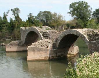
Saint-Thibéry (Cessero) - where the Via Domitia
crosses the Hérault - see photo of bridge above right
Béziers
(Baeterris)

 Narbonne
(Narbo Martius) At Narbonne a section of
the Via Dominitia is exposed in the Place de l'Hôtel
de Ville - See photograph on the right.
The Via Domitia crossed the Aude (known to the Romans as
the Atax) by a seven-arched bridge at the site of the Pont
des Marchands.
Fitou (Ad Viscensimum)
Salses (Ad Salsulae)
Perpignan.
To the south of Perpignan and the hill-fort of Ruscino,
the Via Domitia takes two routes. One runs along the
coast, passing through Elne and the hill-fort of Illiberris,
then through Port-Vendres. The other route runs inland,
passing through Le Boulou, Les Cluses and the passes of
Le Perthus and Panissars.
Ruscino where the road separates in two: the Inland
Route and the Coastal Route.
|
Inland Route
Montescot
Le Boulou
Cluses (Clausurae). The remains of two Roman
forts at Les Cluses overlook the Via Domitia.
The road is still clearly visible in the depths of
the Rom Gorge, a convenient point for the Romans to
control the movement of people (and armies), and to
charge tolls. The road then lead over the Pyrenees
to the south of the Panissar pass, near Perthus.
Le Perthus (Pannissars) Col de Pannissars.
Here the Via Domitia passed between the two triumphal
pillars (30m by 15m), which formed a triumphal arch.
You can still see the foundations of this monument,
which was built in 71 BC by Pompey, to commemorate
victories over the Hispanic peoples. On it were
engraved the the names of the 876 towns where the
rebellion was crushed. From here, there is a
panoramic view over Spain, including the road, known
from here as the Via Augusta. Also at Panissars
you can still see where the Via Domitia was hewn out
of the living rock.
|
|
Coastal Route
Elne (Illiberris)
Saint-Cyprien
Argelès
Collioure
Port-Vendres (Portus Veneris)
Banyuls
|
The two branches rejoin at La Junquera (Deciana) where
the Via Augusta begins.
To take a virtual tour of the Via Domitia, visit http://www.viaeromanae.org,
to open a new window to the site, click here.

![]()

![]() The
Via Domitia, the oldest Roman road in Gaul, and one of the
oldest Roman roads anywhere. It links Rome in Italy
to Cadiz in Spain, and is part of an immense road network
of more than 70,000 miles, built by the Romans
over eight centuries. It runs from one end of the
Languedoc-Roussillon
to the other, through four of the five departéments
of the Languedoc-Roussillon
(Aude,
Gard,
Hérault,
and Pyrénées-Orientales).
only 15 miles or so from the Mediterranean
Sea, providing an easy way to explore the region's landscapes
and history.
The
Via Domitia, the oldest Roman road in Gaul, and one of the
oldest Roman roads anywhere. It links Rome in Italy
to Cadiz in Spain, and is part of an immense road network
of more than 70,000 miles, built by the Romans
over eight centuries. It runs from one end of the
Languedoc-Roussillon
to the other, through four of the five departéments
of the Languedoc-Roussillon
(Aude,
Gard,
Hérault,
and Pyrénées-Orientales).
only 15 miles or so from the Mediterranean
Sea, providing an easy way to explore the region's landscapes
and history. 
![]() The
road allowed Rome to control the wholeof southern Gaul,
distributing agricultural land to Roman
colonists and building new towns along the way.
Apart from exchanges between Rome and its colonial cities,
crossroad settlements developed all along the road, linking
it with neighbouring towns, and creating a new the local
economy.
The
road allowed Rome to control the wholeof southern Gaul,
distributing agricultural land to Roman
colonists and building new towns along the way.
Apart from exchanges between Rome and its colonial cities,
crossroad settlements developed all along the road, linking
it with neighbouring towns, and creating a new the local
economy. 
 Embrun
(Eburodunum)


